Santa Brígida

LOCATION: Amer
ALTITUDE: 470 meters
TYPE: Regular
WIND DIRECTION: S, SW
HEIGHT DIFFERENCE: 180m

ACCESS: From the town of Amer, drive through the "Ruta de les Ermites". Pass the football field, steep road till the restaurant "La Masia d'Amer", where the landing field is. From here you can drive a 12 minutes jeep track to the take off or walk up in 25 minutes.
COORDINATES: LAT 42.021642ºN / LONG 2.612590ºE

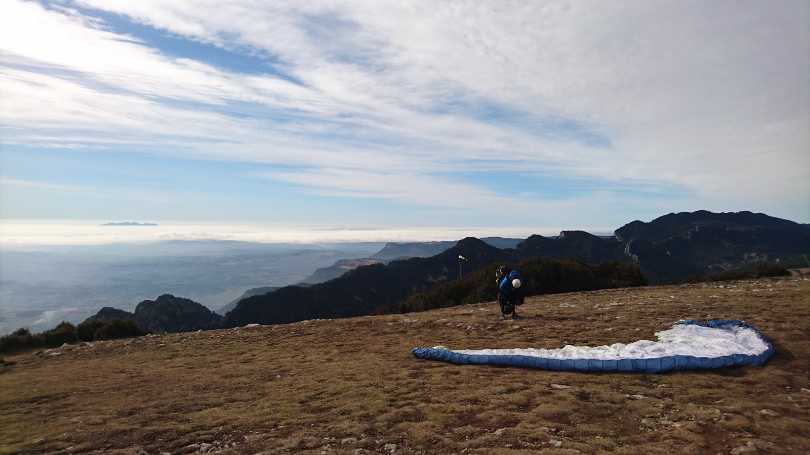
DESCRIPTION: Flat and easy take off (top landing is possible). Small but very reliable site that works all year around. It's very protected from strong meteo winds making it possible to fly many days when other sites near by are not. Some thermas wuick in the mornings. Soaring in the afternoons. During summer middays the breeze can get too strong and you need to wait till afternoon to be able to fly.

LANDING: the official landing is down below the restaurant "La Masia d'Amer", next to the track on the way up.

Coordinates landing: 42.016545ºN 2.607821ºE

CAUTION: West winds can be turbulent.

Read more »

Bellmunt

LOCATION: Sant Pere de Torelló
ALTITUDE: 1187 meters
TYPE: Regular flying site. XC.
WIND DIRECTION: S, SW
HEIGHT DIFFERENCE: 560m
ACCESS: From Sant Pere de Torelló town, drive 15' up to the church of "Santuari de Bellmunt". At the parking walk down for less than 3' to reach the take off.
COORDINATES: LAT 42.100097ºN / LONG 2.293589ºE

DESCRIPTION: Grassy and steep take off, facing SW. Wait for the right wind cicle to start as the takeoff is not orientated to the morning breeze.

LANDING: the official landing is in the town of Sant Pere de Torelló, next to the cemetery. The approach area is higher than the landing field (and close to tall trees), make sure you come at the right altitude to avoid overshoting the landing. Can be turbulent in East or West winds.

Coordinates landing: 42.078759ºN 2.288967ºE

CAUTION: West winds can get strong. East can be turbulent (and the take off then in the lee side).


bellmunt parapent paragliding
flying in the flatlands in front of Bellmunt
Read more »

Pineda

LOCATION: Turó de la Guardia, Pineda de Mar, Maresme
ALTITUDE: 215 meters
TYPE: Alternate. Soaring
WIND DIRECTION: S, SW
HEIGHT DIFFERENCE: 180m
ACCESS: 25 minutes drive from Pineda de Mar town.
From Pineda de Mar town, take the road towards the village of Santa Susanna (3rd exit of the round about with a Macdonalds, street "del Bou". Before to reach the center of Santa Susanna, passed the football field on the left side, turn left to the path "Font el Boter". It's a jeep track so not accessible for al vehicles. You have few places to park on the way, then keep walking on the main jeep path till you find a walking path to the take-off (GPS recommended).
You have also the option to park in the street "Fray Angelico" of Pineda de Mar and walk the rest to the take-off.

COORDINATES: LAT 41.641827ºN / LONG 2.688913ºE

BEST KNOWN FOR: Glassy smoth sea breeze Soaring (mostly late afternoons in summer).

DESCRIPTION:
Pineda was a regular soaring site in the early 2000. Now not so many pilots visit the site but the take-off is still in perfect conditions. It's a sea breeze site, so expect to be able to soar on mid-spring and all afternoon summers. Calella and Pineda are english / german tourist destinations with few pubs for the after-flying.

LANDING:
There is no official landing now. Local pilots usually topland. Don't force it if it's windy, the rotor can be very powerful and you will spend the day taking your glider down from a pine tree. There are optional fields between the main road and the neighbourhood in the same hill. Is probably a good idea to take a look at them before you go up.

Coordinates possible landing (to check if it's still available): 41.636414ºN 2.689553ºE

CAUTION: Westerly winds can be gusty near. In summer the sea breeze can be too strong in the middle hours of the day.
Read more »

Àger - Coll d'Ares

LOCATION: Àger, Montsec
ALTITUDE: 1550meters
TYPE: Regular
WIND DIRECTION: S, SW
HEIGHT DIFFERENCE: 930m
ACCESS: 25 minutes drive from Àger.
From Àger town, take the road towards north next to the cemetery, on the way to the restaurant El Macierol. Keep the tarmac road all the way up to the top where you can find a large parking next to the take-off.

COORDINATES: LAT 42.121371ºN / LONG 1.824268ºE

BEST KNOWN FOR: XC long distance potential (towards East).

DESCRIPTION:
Àger is a well-known XC area but it's also suitable for beginners and new pilots during the smooth hours. You have different take-offs depending wind intensity and direction. Ask to local pilots and schools to get the best information about weather and where to go.

LANDING:
The main official landing is next to the Camping Vall d'Àger. If you don't make it in your glide from the ridge you have other landings from the local schools.

Coordinates landing in Camping Vall d'Àger: 42.003977ºN 0.766886ºE

CAUTION: Easterly winds can be gusty near the landscape. In summer thermal and wind conditions can be strong in the middle hours of the day and jsut for experienced pilots.

Àger and its two ridges

Àger's take-off
Read more »

Figuerassa

LOCATION: Berga
ALTITUDE: 1485meters
TYPE: Regular
WIND DIRECTION: S, SW
HEIGHT DIFFERENCE: 700m
ACCESS: 25 minutes drive from Berga.
Take the road from Berga towards "Rasos de Peguera". After the cross road of "Santuari de Queralt" road, keep going up to "Rasos" and then turn in the first right road towards "Mirador de la Figuerassa". From here you will be in a jeep path till the top(usually in a good shape for any car, watch out for snow in winter).

If you want to hike up, you can get the GPS hiking track from here: http://ca.wikiloc.com/wikiloc/view.do?id=6128996

COORDINATES: LAT 42.121371ºN / LONG 1.824268ºE

BEST KNOWN FOR: Good morning school take off.

DESCRIPTION:
Grassy wide take-off next to two communication antennas. The take-off gets more narrow at the end, so it's important to have a good straight wind and run to don't drift in to the bushes! In good days it's possible to soar the ridge on the left or find some morning thermals, but keep the altitude of the take-off to be able to glide across the next ridge south towards Berga (where the nice landings are). Watch out for the rotor of the south ridge when low while crossing it. If you can't cross the next ridge (Queralt) because strong wind or low altitude, you have small landings options at the foothill of Figuerassa (not recommended for beginners). If you crossed, once in the south face of Queralt, you can keep your flight soaring or thermalling.
For more Hike&fly in the area visit: http://ca.wikiloc.com/wikiloc/user.do?id=969161

LANDING:
The official landing is in Avià, the town on the south, accross the industrial area. If you are too low to reach it there are few unofficial fields (just for emergency landings) over the industrial area (when not cultivated). Watch out for power and phone lines. Respect the crops, don't land close to cows and specially horses. Pack outside of those fields.

Coordinates Volem landing in Avià town: 42.083940ºN 1.822603ºE
To land at the official landing of "Volem" paragliding school you must contact them previously.


CAUTION: West winds can increase their speed quite fast (front coming or just passed) and can be gusty. You need a good glide or good altitude to cross the ridge in front (Queralt) and get in to the good landing options.

Gliding high from Figuerassa to Queralt
Pre-flight at the take-off in a dry winter
Read more »

Ensija

LOCATION: Berguedà
ALTITUDE: 2270meters
TYPE: Hike&fly site. XC.
WIND DIRECTION: S, SW, W
HEIGHT DIFFERENCE: 600m
ACCESS: 30 minutes drive from Berga + 1h30min of hike.
Take the road from Berga towards Puigcerdà (C-16). Just after the thermic central turn left to BV-4025 road towards Fígols. Pass the town and drive till coordinates 42.167476ºN 1.775336ºE where you can park and start the hike. The hike follows a narrow and direct path on the south face of Ensija to the top of the mountain. At the top, go left (west) to reach the best take off area.
You can get the GPS hiking track from here: http://ca.wikiloc.com/wikiloc/view.do?id=6441081

COORDINATES: LAT 42.179220ºN / LONG 1.757011ºE

BEST KNOWN FOR: Great hike and fly with beautiful views. Good XC possiiblities.

DESCRIPTION: Great place to hike and fly in the first ranges of the Pyrennees with perfect views of the XC area of El Berguedà. It's also a good XC start or top landing for bivy flying (there is a hut close by the take off area). It's facing south and west. Pilots took of also to north (in very light wind) from the highest summit of Ensija but never tried personally.
With some logistics you can do few hike&fly the same day to reach Berga (south).
On the way up/down with the car you can stop at "Fumanya" and visit the "Titanosauridae" dinosaur footprints.

For more Hike&fly in the area visit: http://ca.wikiloc.com/wikiloc/user.do?id=969161

LANDING: Coordinates landing in Peguera: 42.163417ºN 1.767065ºE
To get back to the car you will need to walk some 10 to 15 minutes. Go first downhill towards the East and then follow up the jeep path towards the parking.

CAUTION: West winds can increase their speed quite fast (front coming or just passed).

Taking off in winter

hiking up for some 600 meters up in a corridor.
The landing in Peguera.
Read more »

Rasos de Peguera

LOCATION: Castellar del Riu (next to Berga).
ALTITUDE: 2030 meters  
TYPE: Regular flying site. XC.
WIND DIRECTION: S, SE
HEIGHT DIFFERENCE: 1200m
ACCESS: From Berga city, drive 25' up to "Rasos de Peguera". At the end of the road you will find a parking. Walk up the old ski slope to the right (towards East, from the parking) for 15' and at the top you will find the grassy take off.
COORDINATES: LAT 42.105801ºN / LONG 1.824471ºE

BEST KNOWN FOR: XC triangles towards N and W.
Long flight descend in calm conditions for new pilots.

DESCRIPTION: High take off in the Pre-Pyrennees and a good XC start. It's facing south, so late in the midday or afternoon, when winds turn into SW you might find cross wind at the take off. It's not a very protected mountain, so better to go uphere when the forecast of altitude wind is light.
Early in the day it is suitable to new pilots but you need a clear flight plan as you need some altitude to cross a couple of saddles towards Berga.

LANDING: 1 official landing in Avià, the town on the south, accross the industrial area. You need to cross before a big sadle ("coll gran"). Consider in summers that the breeze might be stronger down in the valleys.
If you can't cross the big saddle/col you have an alternative big landing area before, called Campllong, next to a road.


Coordinates Volem landing in Avià town: 42.083940ºN 1.822603ºE
To land at the official landing of "Volem" paragliding school you must contact them previously.

CAUTION: West winds are usually strong and turbulent.

Read more »
Powered by Blogger.